

Seismotectonic description
BETIC-BALEARIC AREA
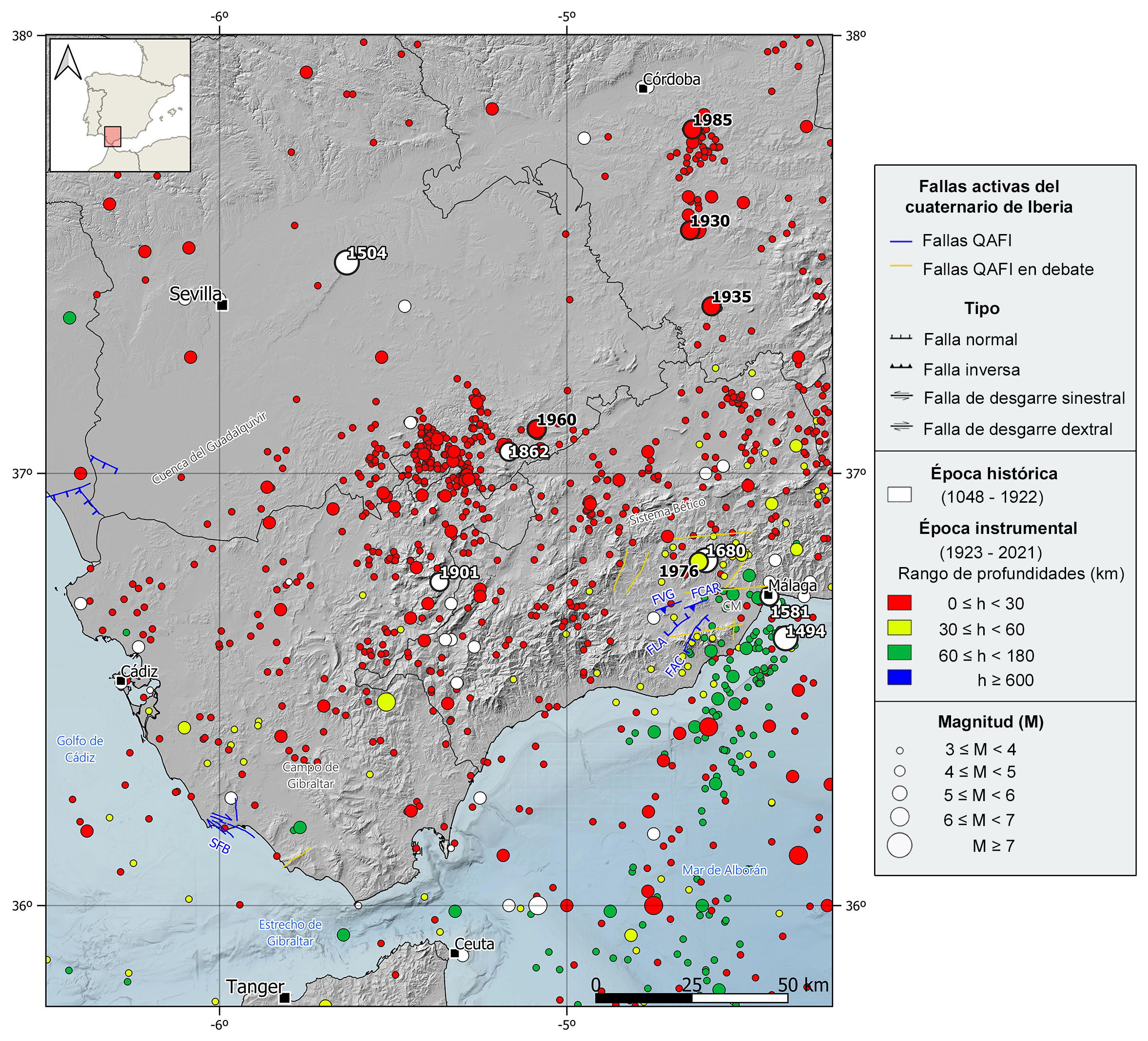
Seismic information source from the National Geographic Institute (IGN) (https://doi.org/10.7419/162.03.2022). Raster cartography of Spain from the IGN CC BY 4.0 ign.es. Geological data source: Thematic map of the National Atlas of Spain (ANE) CC BY 4.0 ign.es (2020), synthesis based on the IGME-SGE Geological Map of Spain 2M (2004) and the IGME-LNEG Geological Map of Spain and Portugal 1M (2015). 50% transparency. Main Quaternary active faults compiled from the QAFI data base (García-Mayordomo et al., 2012; ( IGME, 2022).FAC: Acebuchal Fault, FCAR: Cartama Fault, FLA: Los Alamillos Fault, FVG: Villafranco de Guadalhorce Fault, SFB: Barbate Fault system. CM: Málaga Basin.
GEOLOGICAL CONTEXT AND TECTONIC FRAMEWORK
The western zone of the Betic Cordillera covers the region between the Guadalquivir River mouth and the Málaga city, the southern limit is the Cádiz and Málaga coastlines and the northern limit is the Guadalquivir basin along the province of Sevilla.
Geologically speaking, despite in this region are present the Subbetic unit of the Outer Zone in the northern part and the Maláguide and Alpujárride complexes, as well as the associated peridotitic masses of the Inner Zone in the southern part, it is the Campo de Gibraltar unit the most representative one in this region. This unit or intermediate domain is characterized by the presence of cretaceous and paleogen turbidites that were deposited in the sea separating the Inner and Outer Zones previously to the Betic Cordillerra uplift. This sea was seated over an early-stage ocean ridge where new oceanic crust was generated and afterwards got aborted and became part of the Betic Cordillera when it got formed. The strong folding affecting this turbidite deposits during the Alpine orogeny was responsible of the current and characteristic vertical configuration, this area is known as the Campo de Gibraltar flysch
Within the most recent sediments partially covering the oldest formations in this area, it stands out the Olistotromic Units that are distributed in the vast majority of the central and northern zones. This unit was developed during the Miocene, contemporary to the mountain range uplift, and it is a wedge-shape complex formed by different depositional units, some of them with gravitational origin and formed with some sediments coming from the Outer Zone units and others coming from the Guadalquivir basin sedimentary infill.
Tectonically, the regional compressive stress field derived from tectonic and seismic data is compatible with the NW-SE compression observed in GNSS data. In this regional context dominated by the NW-SE oblique convergence between the African and Eurasian plates, in the Western Betic Cordillera this convergence gets more tangential. The knowledge of active faults in the area is very limited, mainly reverse and strike-slip faults, due to the lack of ground expression. The neogene Málaga basin, westwards of Málaga city and bounded by the Outer Zone units, concentrates most of the active known faults, among which, the ENE-WSW reverse Cartama and Villafranca de Guadalhorce faults and the NE-SW normal Los Alamillos and El Acebuchal faults stand out. It is also noteworthy the Barbate fault system, mostly WNW-ESE strike-slip system with a N-S normal fault branch.