TECTONIC FRAMEWORK
The Pyrenees raised during the Alpine orogeny, a large-scale tectonic process active since the late Mesozoic and during most of the Cenozoic. At small scale, this orogeny was linked to three tectonic events creating a compressive stress field responsible of the Iberian Peninsula evolution. In the northern area, the subduction of the oceanic crust in the Gulf of Bizkaia under the Iberian plate and the collision of the Iberian and Euroasian plate were responsible of the Cantabrain Mountain Range and the Pyrenees uplift respectively. In the southeast area of the Peninsula, the collision between the Alboran and Iberian plate created the Betic System.
In the current Pyrenees region, the pre-orogeny stage was dominated by an extensional regime that created mesozoic sedimentary basins infilled with jurassic and cretaceous thick marine sediment series.
During the orogenic stage, the Pyrenees were uplifted and folded, involving both the paleozoic basement and the mesozoic sedimentary basins. Moreover, it created the source rock area of the cenozoic sediments that were deposited in the foreland basins to the north and south of the mountain range (Aquitaine and Ebro basins).
In this orogenic stage, the oblique convergence, collision and subduction of the Iberian microplate under the Eurasian plate, resulted in a transpressive and compressive stress field that lasted till the Miocene (late Cenozoic). The mountain relief started appearing at the east and was progressively moving westwards as the subduction process advanced and the oceanic trough separating Iberia and Europe mainland in the western area got closed.
Therefore, the Pyrenees is a fossil plate boundary between the Iberian and Eurasian plates and its surface expression is the North Pyrenean fault, a large tectonic structure crossing the Pyrenees from east to west.
The current post-orogenic stage started with the relax and ending up of the Alpine orogeny and does not show a dominant stress field. Nevertheless, geodesy data shows a very slow extension perpendicular to the mountain range, where the main active faults are normal faults and result from the reactivation and inversion of reverse fault of the orogenic stage.
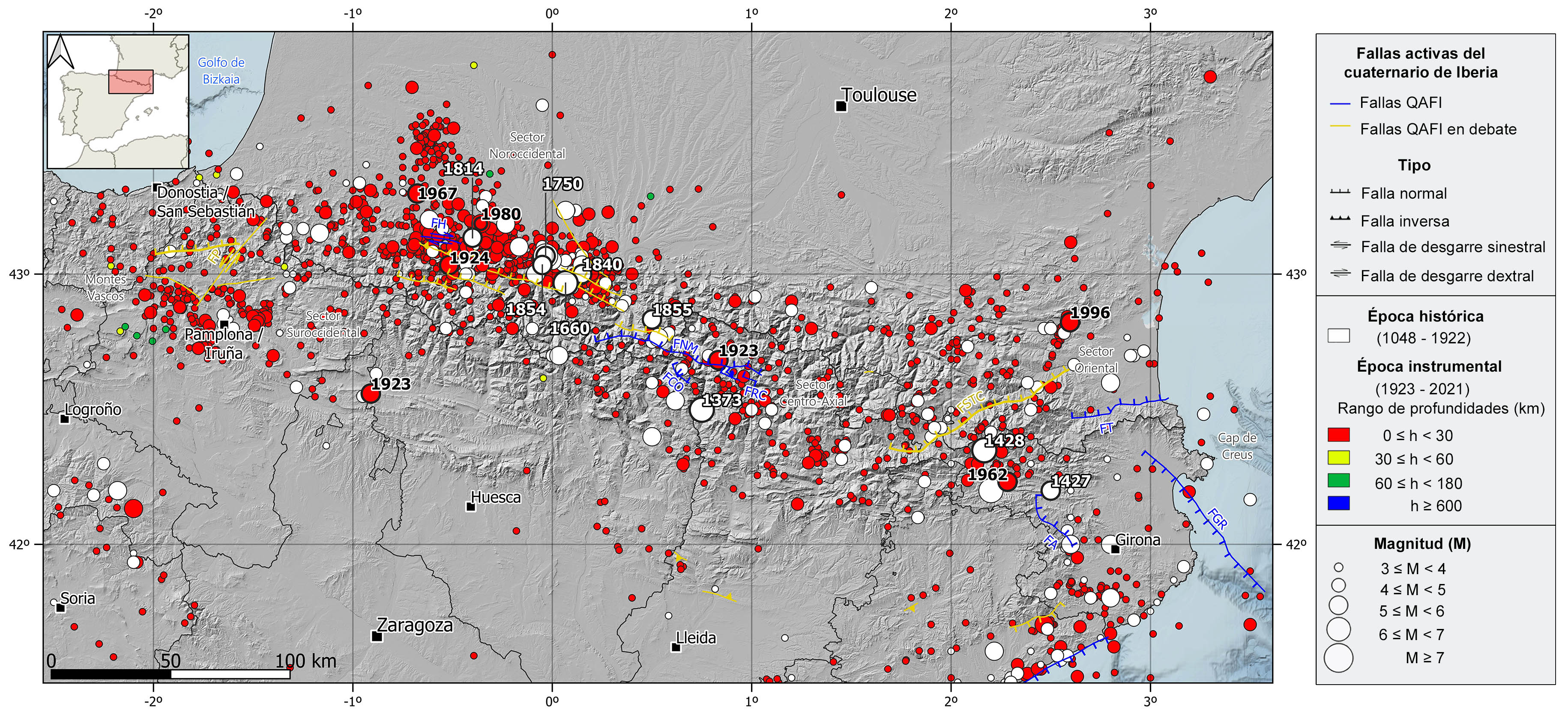
Regionally, the Pyrenees Mountain Range can be split in four different sectors with some remarkable active fault series. In the eastern sector, the Sud de la Tet-Cerdanya fault system which extends NE-SW along 120 km, the ENE-WSW Tech faults and the NW-SE Amer and Gulf of Roses faults. In the Center-Axial sector, numerous E-W to WNW-ESE faults strongly dipping to the north and with associated seismicity, the Coronas, Rius-Cabanes, and Maladeta North faults are the best examples. In the northwestern sector, the WNW-ESE dextral strike-slip Herrere fault and many normal type structures with similar orientation whose quaternary tectonic activity is under debate. In the southwestern sector, there are several faults whose recent activity is currently under debate, the NNE-SSW sinistral strike-slip with normal movement component Pamplona fault is the main one.
The current deformation rate in the Pyrenees is very low, below 1 mm/yr, but nevertheless, the Pyrenees shows a continuous seismic activity and is the second most active seismic region in the Iberian Peninsula.
REGIONAL OVERVIEW AND GEOLOGICAL CONTEXT
The Pyrenees is one of the largest mountain chains in the Iberian Peninsula. It is located in the NE part of the Peninsula and extends from the Cape of Creus in the Mediterranean Sea to the Gulf of Bizkaia in the Cantabrian Sea. It is over 400 km long in E-W direction and reaches 150 km wide in its central part. There are many summits over 3000 m high, such as the Aneto, Posets, and Monte Perdido peaks, and few minor glaciers retreating. The Pyrenees is the natural border between the Iberian Peninsula and mainland Europe.
Westwards, the Pyrenees continue with the Basque Mountains and the Cantabrian Mountain Range, creating the Pyrenees-Cantabrian axis from the Mediterranean Sea to Galicia along over 1000 km. Geologically speaking, this axis is a single structure with the same origin which is linked to the Alpine orogeny. Nevertheless, the Pamplona fault is considered as the separation line between the pyrenean and cantabrian domains.
The Pyrenees presents a quasi-symmetrical structure where the oldest rocks, basically paleozoic granites and metamorphic rocks, are heavily folded and integrate the rock outcrops in the axial or central part of the mountain chain. On top of this paleozoic basement there is a discordant sedimentary cover of mesozoic and cenozoic age. The mesozoic sedimentary rocks surround the axial part and are composed by a wide range of lithologies, among which the rocks of marine origin and the evaporites that play a detachment role in many thrust faults are remarkable. The cenozoic rocks are mainly continental and correspond to the foreland basin sedimentary infills to the north and south, the Aquitaine and Ebro basins respectively, which were formed during the mountains uplift.
HISTORICAL AND INSTRUMENTAL SEIMICITY
The Pyrenees is characterized by a moderate-magnitude seismicity, mainly of shallow depth ( <30 km)), although in this region the crustal thickness can reach 50 km depth in some areas. The predominant focal mechanisms are of normal fault type, with the stress axes perpendicular to the mountain range, in concordance with the actual tectonic regime and the GNSS observed displacement data.
The eastern sector of the Pyrenees presents a moderate and scattered seismic activity, but it has also been hit by some large destructive historical earthquakes. During the historical period, it is noteworthy the 1427-1428 seismic series, with the occurrence of several earthquakes of estimated magnitude above 6 in the province of Girona: the 1427 event in Olot, with maximum intensity of VIII-IX, and the 1428 event in Queralbs. The latter had a maximum intensity of IX-X and caused the destruction of the city and about 800 casualties. During the instrumental period, it can be noticed the 1962 (M5.2) and the 1996 (M5.1) earthquakes in the province of Girona and the eastern sector of the French Pyrenees, respectively.
In the central sector of the Pyrenees, in the historical period, it is worth mentioning the 1373 in Ribagorça (Lleida) earthquake with intensity VIII-IX and estimated magnitude of 6.2. During the instrumental period, stands out the 1923 Vielha (Lleida) earthquake with intensity VIII and estimated magnitude around 5.8. Several studies suggest the Maladeta North fault as the possible source of both events.
The northwestern sector is the most seismically active region of the Pyrenees, highlighting two historical earthquakes with estimated magnitude around 6: the 1660 Bagneres-de-Bigorre and the 1750 Lourdes earthquakes, with maximum intensities of VIII-IX y VIII, respectively. Several other significant events have occurred in this region, the largest of estimated magnitude 5.8 and intensities VII and VII-VIII in 1750, 1840, 1854, and 1855. Further west, there was also an important earthquake in 1814 in Arduy of intensity VII-VIII. During the instrumental period, there are noteworthy the 1924 Laruns, and the 1967 Arette earthquakes, both of magnitude 5.4 and intensity VIII, and the 1980 Arduy event of magnitude 5 and felt with a maximum intensity VII. To the south of the Pyrenees, it is also worth mentioning an earthquake in 1923 in the Canal of Berdún (Huesca-Zaragoza) of intensity VII and magnitude 5.7.
Finally, in the southwestern region, in the boundary with the Basque Mountains, the most relevant seismicity, of lower magnitude and intensity than in the rest of the Pyrenees, clusters around the city of Pamplona, where several earthquakes of magnitude between 4.5 and 5 and maximum intensities V and VI, have been recorded in 1903, 1982, 2004, and 2020.