TECTONIC FRAMEWORK
The Coastal Catalan Range is an intraplate structure raised during the Alpine orogeny. This orogeny, caused by the collision between the Iberian and the Euroasian plates during the Cenozoic, lead to a N-S compressive stress field responsible of the uplift of the Pyrenees. These forces were transmitted to the SW with a strong oblique component along an ‘en-échelon’ fault system causing the folding and uplift of the Coastal Catalan Range rocks.
This mountain range shares origin and age with the Iberian Chain, but it is a tectonically independent structure. The linkage between both chains is through the area called transition zone where the NW-SE Iberian Chain structures and the NE-SW Coastal Catalan Range structures interfere. This transition zone extends north to south from the Tivissa mountains to the northern area of the Maestrazgo.
After the uplift, the system changed to be controlled by an extensive regime linked to the opening of the Valencia Trough. The rift system forming the Valencia Trough continues northwards entering the European continent. It began to open in the Miocene and defined the current position of Corsica and Sardinia Islands, as well as the Balearic Islands. It also triggered volcanic episodes like the ones in the Garrotxa region (Girona) and the creation of different sedimentary basins.
The current thermal subsidence phase in the Valencia Trough is responsible of the extensive tectonic and therefore the stress field perpendicular to the main tertiary normal faults controlling the zone. In summary, the Coastal Catalan Range is an intraplate zone of low deformation, characterized by normal faults with slow movements of around 0.1 mm/year.
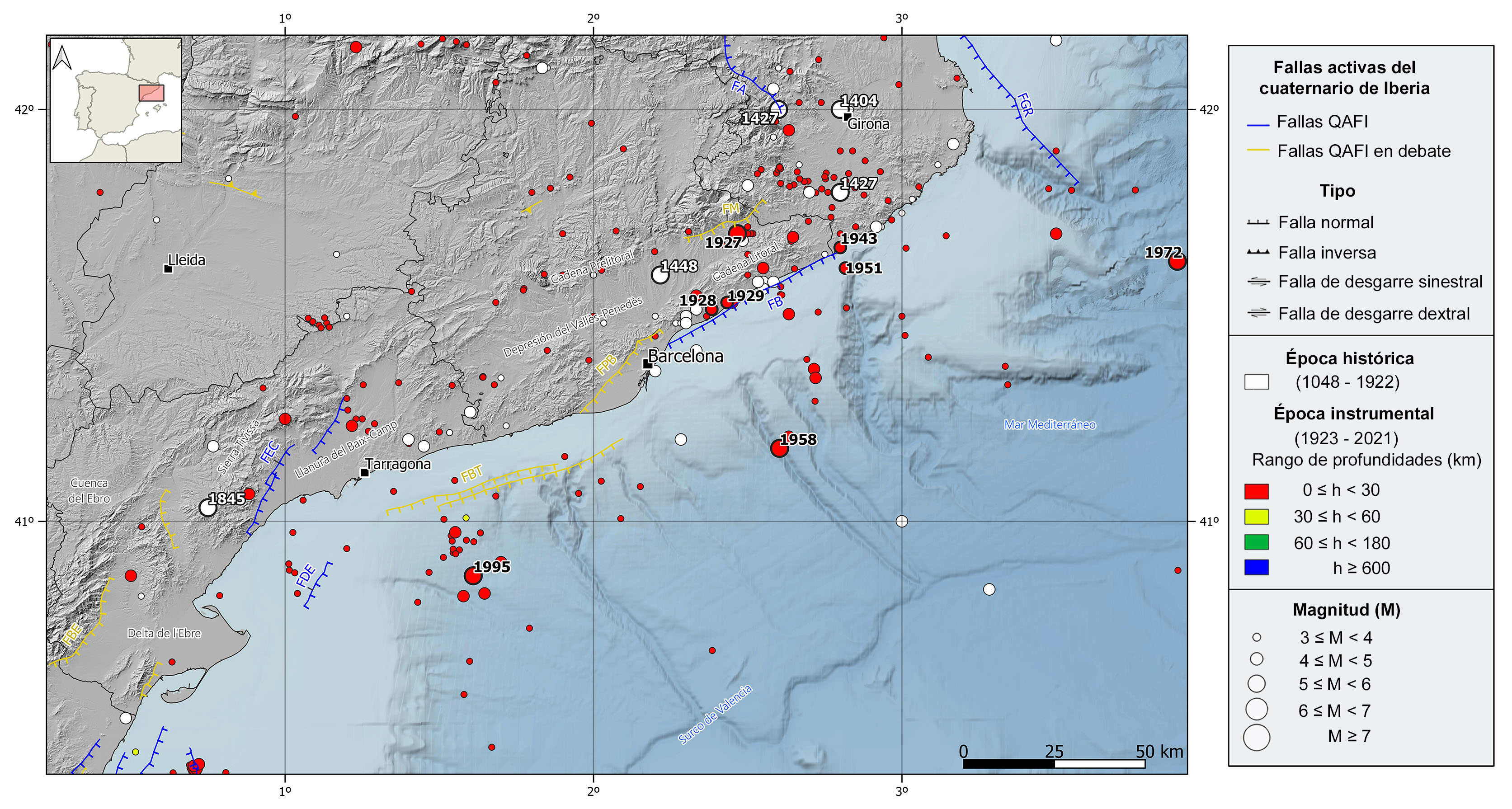
The main active normal faults identified in the area are, from north to south, the NW-SE Gulf of Roses and Amer faults, and the NE-SW Montseny, Barcelona, Camp and Delta of Ebro faults. These faults show both activity in recent times (Pliocene and Quaternary) and associated instrumental seismicity, except for the Delta of Ebro fault. The Pla of Barcelona and the Barcelona-Tarragona faults, in the vicinity of the Barcelona city, and the Baix Ebre fault, to the west of the Ebro River Delta, are also remarkable due to their long extension. Anyway, the activity of these three faults is under discussion.
REGIONAL OVERVIEW AND GEOLOGICAL CONTEXT
This region encompasses both the Coastal Catalan Range and the northernmost part of the Valencia Trough.
The Coastal Catalan Range is a mountain chain joining the Eastern Pyrenees with the northeast foothills of the Iberian Chain, from the Gulf of Roses to the Ebro River Delta. It extends in an NE-SW direction along 250 km parallel to the mediterranean coast with 40 km on average wide.
This mountain range is formed by two parallel alignments, the Coastal Chain, running close to the sea and even submerged under the Mediterranean Sea in its most southern portion, and further inland, the Pre-coastal Chain that hosts the highest summits (Montseny peak, 1712 m). Between both reliefs there is an elongated basin called Catalan Pre-coastal depression (or Vallès-Penedès depression) with continuity to the south with the Baix Camp Plain.
The Valencia Trough is a marine basin that extends from Valencia to Girona, including the Baleriac Islands.
Geologically speaking, this region presents a high variety of lithologies from a wide range of ages. The oldest rocks belong to the Variscan basement, continuation of the Iberian Massif, that it is formed mostly by paleozoic granites and methamorfic rocks. Placed on this basement there are very thick and discordant series of sedimentary rocks of mesozoic and cenozoic ages deposited in rift basins linked to the Tethys Ocean opening. The more recent tertiary basins (tectonic grabens) are mostly fill of unconsolidated clastic materials.
HISTORICAL AND INSTRUMENTAL SEIMICITY
The seismicity of this region is characterized by low to moderate magnitude earthquakes, mostly at shallow depths (< 20 km) and mainly located in the northern and central end of the mountain range, as well as in the Mediterranean Sea, offshore the coasts of Tarragona and Barcelona.
In the historical catalog, the seismicity is mainly located in the northern sector. It is worth mentioning the 1427 Amer (Girona) seismic series which is attributed to the Amer fault. From this series, at least five earthquakes had intensity greater than VII, one of them reaching intensity VIII, and estimated magnitudes between 5.4 and 5.9. There can be also pointed out other several events in this region with slightly lower intensities, between VI and VII, and estimated magnitudes between 5.4 and 5.7, the 1404 Girona, 1427 Caldes de Malavella (Girona), 1448 Cardedeu (Barcelona), and 1845 Tivissa (Tarragona) earthquakes.
In instrumental period, however, there are no earthquakes of magnitude larger than 5.0 in this area, except for the 1927 earthquake in Sant Celoni (Barcelona) with an estimated magnitude of 5.4 and felt with a maximum intensity of VII. Among the largest earthquakes in the instrumental catalog, we can highlight the 1928 and 1929 M4.9 events occurred in Cabrils and Mataró (Barcelona) and felt with maximum intensities VI and V, respectively. More recently, it can be mentioned the 1943 (M4.5) Blanes (Girona) and 1951 (M4.6) Calella (Barcelona) earthquakes, both felt with intensity V. With epicenter in the Mediterranean Sea, we can point out the 1958, 1972, and 1995 earthquakes of magnitude around 5 and felt with maximum intensities between IV and V.