TECTONIC FRAMEWORK
The current state of the northwestern portion of the Iberian Peninsula is the result of a complex tectonic evolution in which three different phases are distinguished.
The first tectonic phase is compressive and linked to the Hercynian orogeny, origin of the Iberian Massif. This orogeny shows different phases and was active along most part of the mid and late Paleozoic. Its origin is the collision between the Euroamerican and Gondwana landmasses that ended up with the formation of the Pangea supercontinent.
The second tectonic phase is distensive and active along the Mesozoic. During this phase the Atlantic Ocean opened and therefore Pangea supercontinent got fractured. In the case of the northern margin of the Iberian Peninsula, its evolution was controlled by the counterclockwise movement to the SE of the Iberian plate independently from the rest of Europe. This movement resulted in the separation of the Eurasian and Iberian plates and the subsequent opening the Gulf of Bizkaia.
The third tectonic phase is compressive and active along the Cenozoic. It is related to the Alpine orogeny caused by the collision between the Eurasian and the African plate. This event resulted in an opposite geodynamic regime compared to the previous phase, and as a consequence of the convergence between Eurasia and Iberia, the partial closure of the Gulf of Bizkaia and the uplift of the Cantabrian Mountain Range occurred.
Because of this complex tectonic evolution, there are a large number of inverse or strike-slip faults of paleozoic age that were reactivated as normal faults during the extensive phase and recovered back as inverse and strike-slip faults during the Alpine orogeny. Some of these faults show evidence of recent activity (Pliocene and Quaternary) and associated seismicity. Three remarkable sinistral transform fault systems exist in the region, the NE-SW Vilachá-Baralla-Becerreá in Lugo, and two NNE-SSW systems, Penacova-Régua-Verín and Manteigas-Vilariça-Bragança, in the NE of Portugal. It is also worth mentioning the NW-SE Ventaniella and Ubierna dextral transform system to the SE of the Cantabrian Mountain Range. Despite the Ventaniella fault is 200 km long inland and extends 150 km more offshore, it is only active in its southern segment.
REGIONAL OVERVIEW AND GEOLOGICAL CONTEXT
This region includes all the northwestern margin of the Iberian Peninsula. It extends along almost 400 km, from the western edge of Cantabria to the Atlantic coast in Galicia. Inland, it covers Galicia and most of the northern side of the Duero River basin. The northern and western part encompasses the western portion of the Cantabrian Mountain Range, including the Picos de Europa mountains, the Leonese Mountains and the Galician Massif. These areas are also characterized by a rugged coast with big cliffs and with almost no coastal plains. In the other hand, the southeast part is a plateau that corresponds to the Duero River basin.
Geologically speaking, this region mainly corresponds to the northern portion of the Iberian Massif, which is the group of precambrian and paleozoic rocks that were mostly deformed and metamorphized during the Hercynian or Variscan orogeny. This orogeny was the origin of a mountain belt, currently quite eroded and partially buried, that in Europe extends along over 3,000 km from the Guadalquivir River to Central Europe and the Balkans. The Iberian Massif is the southern portion of this mountain belt, and it is the best-known record of the Hercynian orogeny effects.
Most of the rock outcrops in the western half of the Iberian Peninsula are from the Iberian Massif, which eastwards is buried in the Duero River basin acting as the basement. The sediment infill of this cenozoic basin is mostly continental and clastic, and its generation and deposition are linked to the Alpine orogeny.
The Iberian Massif is divided in six different zones, three of them belong to the NW Iberian Peninsula region. From east to west, these three zones are the Cantabrian zone, which is the outer part of the Variscan orogen and it is dominated by marine sediments strongly deformed but with low degree of metamorphism and therefore the sedimentary aspect of the rocks remain, the Western-Asturian-Leonese zone, which is a transition area between the inner and outer part of the Variscan orogen and consequently with a higher metamorphism degree, and the Center-Iberian zone, which is the axial part of the hercynian orogen where high degree of metamorphism rocks and granite intrusions dominate. In this last zone, it is worth mentioning the Galicia-Trás-Os-Montes subregion where different ophiolite complexes are known, oceanic crust sections uplifted and exposed during the Hercynian orogeny.
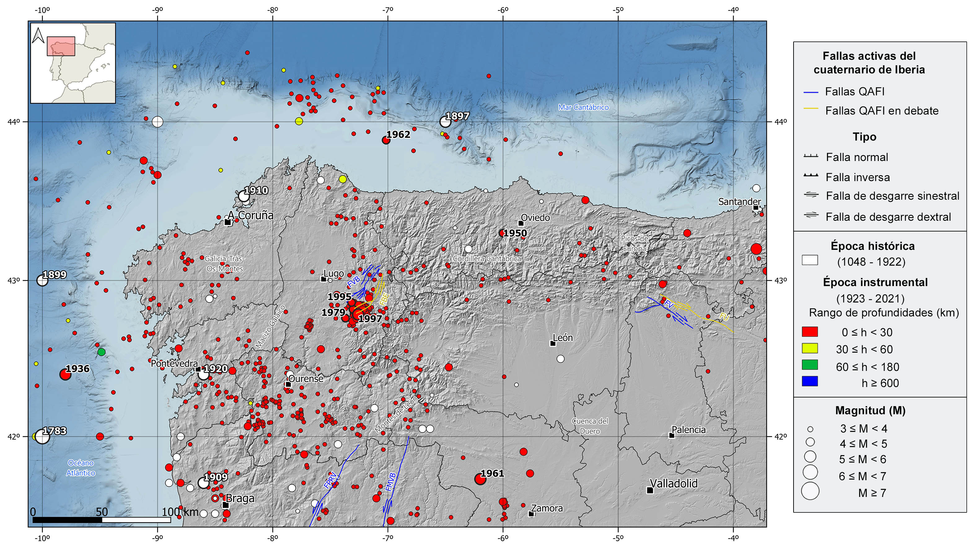
HISTORICAL AND INSTRUMENTAL SEIMICITY
The NW of the Iberian Peninsula is currently considered a seismically stable zone of low to moderate-magnitude seismicity, within the general seismotectonic context of Iberia. Nevertheless, it presents some remarkable seismic series and earthquakes of moderate magnitude. Seismicity in this area is shallow (depths <30 km) and, although scarce, focal mechanisms of normal and strike-slip type predominate. The south and east of Galicia is the area with the highest number of earthquakes, while in the rest of the region seismicity is scattered, with some earthquakes with marine epicenter, both in the Atlantic and Cantabrian coasts.
In the historical catalog we can highlight several earthquakes of estimated magnitudes greater than 5. With epicenter in the sea, the 1783 and 1899 events in the Atlantic Ocean, and the 1897 in the Cantabrian Sea stand out. These earthquakes were felt with maximum intensities of VI-VII, VI, and V-VI, respectively. On land, there are worth mentioning the 1909 Viana do Castelo (Portugal), 1910 El Ferrol, and 1920 Pontevedra earthquakes, all felt with intensity VII. In addition to these, in the first two decades of the 20th century, several earthquakes of intensity VI and magnitude slightly lower than 5 have been catalogued, mainly in the northwest of Portugal and southwest of the province of Pontevedra.
In the instrumental period, three earthquakes of magnitude around 5, felt with maximum intensities of VI, can be highlighted: the 1950 (M4.7) Teverga (southwest of Oviedo) event and two earthquakes occurred in 1961 west of Zamora of magnitude 5.3. But most of the seismicity is concentrated around the Sarria-Becerreá-Triascastela (Lugo) area, where three significant seismic series occurred in 1979, 1995, and 1997, with maximum magnitude earthquakes of 4.6, 4.7 and 5.2, respectively.
With epicenter in the sea, there are also two remarkable earthquakes of moderate magnitude: the 1936 (M5.1) earthquake in the Atlantic Ocean, offshore the coast of Pontevedra, and the 1962 (M4.4) in the Cantabrian Sea, offshore the coast of Lugo. These earthquakes were felt with maximum intensities V and VI, respectively. In the last two decades, there have been some scattered earthquakes in the provinces of Zamora and León and in the Cantabrian and Atlantic coasts, with magnitude slightly above 4 felt with intensities between IV and V.