

Seismotectonic description
BETIC-BALEARIC AREA
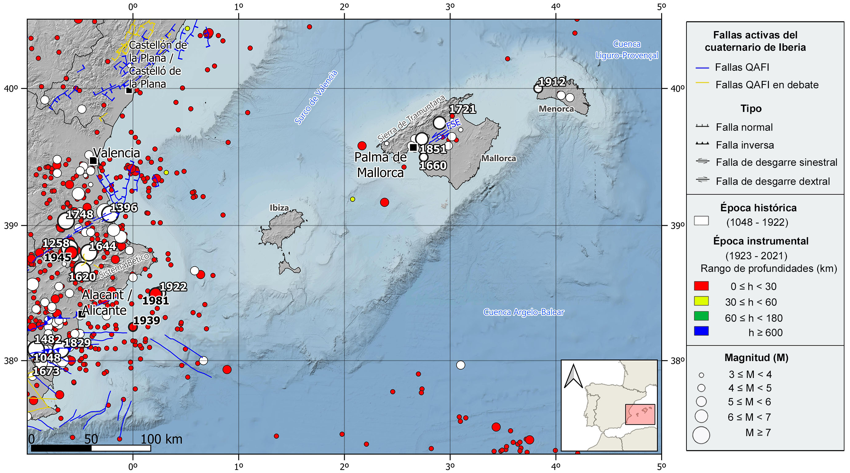
Seismic information source from the National Geographic Institute (IGN) (https://doi.org/10.7419/162.03.2022). Raster cartography of Spain from the IGN CC BY 4.0 ign.es. Geological data source: Thematic map of the National Atlas of Spain (ANE) CC BY 4.0 ign.es (2020), synthesis based on the IGME-SGE Geological Map of Spain 2M (2004) and the IGME-LNEG Geological Map of Spain and Portugal 1M (2015). 50% transparency. Main Quaternary active faults compiled from the QAFI data base (García-Mayordomo et al., 2012; ( IGME, 2022).FSE: Sencelles Fault.
GEOLOGICAL CONTEXT AND TECTONIC FRAMEWORK
The Betic-Balearic domain extends from the most eastern edge of the Betic Cordillera to the Balearic continental block, which correspond to the NE prolongation of the Betic System, and it is attached to the eastern margin of the Iberian Peninsula by its southwestern sector.
This NE-SW Balearic promontory is a broad plateau 400 km long and 100 km wide approximately. It is bounded by three extensional marine basins, to the NW and to the SE on continental crust, the Valencia trough and the Liguro-Provençal basin respectively, and to the SE on oceanic crust, the Algero-Balearic basin.
Geologically speaking and at regional scale, the Balearic Islands are mainly formed by mesozoic and cenozoic carbonatic rocks (limestones and marls) with siliciclastic layers interbedded. These formations correlate mainly with the Outer Zone unit present in the Betic cordillera. It is also worth mentioning the paleozoic rocks outcrops in Menorca, and very locally in Mallorca, that probably correspond to fragments of the Iberian Massif.
Tectonically, this region is very complex and both compressive and extensional processes were involved in its evolution. It can be distinguished a first pre-orogenic phase characterized by an extensive stress field (Mesozoic), a second compressive phase during the Alpine orogeny (Cenozoic), and a third post-orogeny phase of tectonic quiescence (Late Miocene – Today).
During the second phase (alpine compression) in which significant ENE-WSW thrust faults and folds were formed, the extensional marine basins surrounding the Balearic promontory opened and developed. Besides, the promontory was split into three sectors because of the development of NW-SE transcurrent faults. Each sector is governed by one of the main highs of the promontory emerging as the principal islands in the archipelago, from SW to NE, Ibiza, Mallorca and Menorca.
As a result of this tectonic evolution, the Mallorca Island is the most rugged island in the archipelago, and it is characterized by several successive NE-SW horst and grabens. The most western horst is the most relevant one as it shapes the Tramontana Mountain Range. This structure frame in Mallorca is linked to the development of a series of NW-verging thrusts whose detachment level is the triassic evaporites.
Currently, the stress field is very quiet or slightly compressive, and there is almost no seismic activity in the archipelago. It is only worth mentioning one active fault with ground expression, the Sencelles fault located in Mallorca Island. It is a 20 km long NE-SW left-lateral strike-slip fault aligned with the big compressive structures in the island, and a slip rate below 1 mm/yr.