

Seismotectonic description
BETIC-BALEARIC AREA
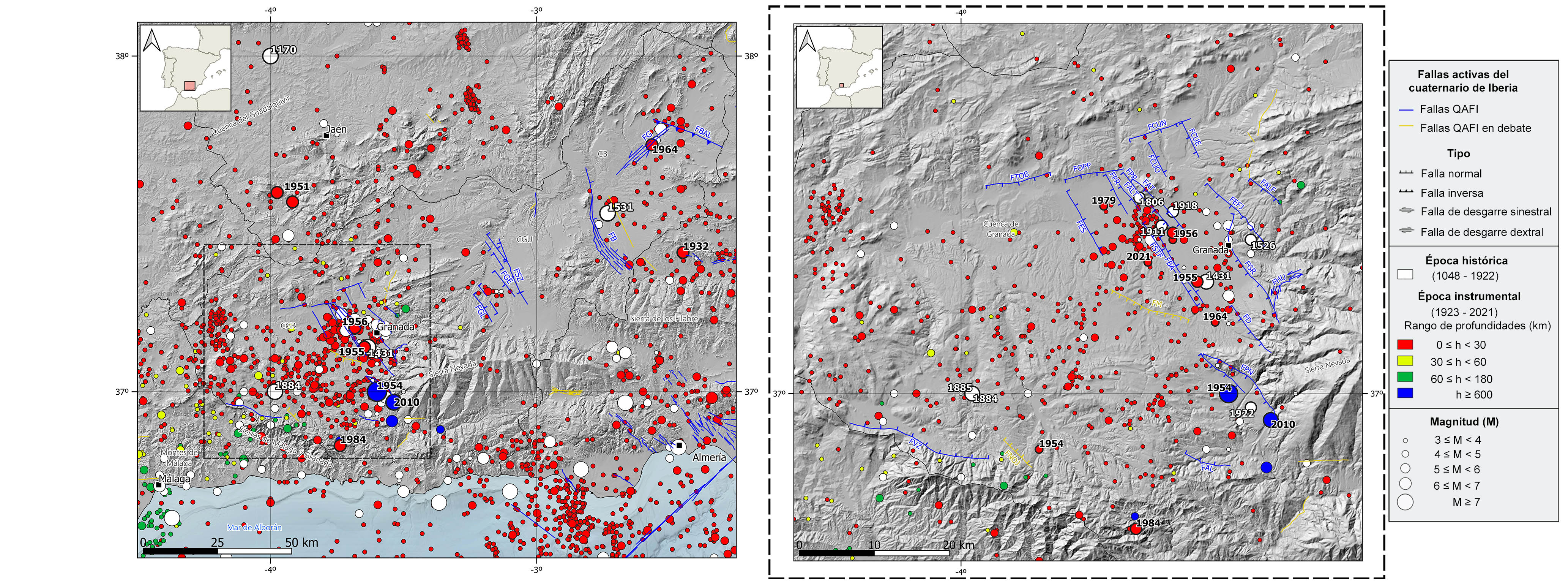
Seismic information source from the National Geographic Institute (IGN) (https://doi.org/10.7419/162.03.2022). Raster cartography of Spain from the IGN CC BY 4.0 ign.es. Geological data source: Thematic map of the National Atlas of Spain (ANE) CC BY 4.0 ign.es (2020), synthesis based on the IGME-SGE Geological Map of Spain 2M (2004) and the IGME-LNEG Geological Map of Spain and Portugal 1M (2015). 50% transparency. Main Quaternary active faults compiled from the QAFI data base (García-Mayordomo et al., 2012; ( IGME, 2022).FB: Baza Fault, FBAL: Botardo-Alfahuara Fault, FG: Galera Fault, FGE: Guadix East Fault, FGL: Graena-Lugros Fault, FSZ: Solana-Zamborino Fault. CB: Baza Basin, CGU: Guadix Basin, CGR: Granada Basin.
DETAILED MAP: GRANADA BASIN. FAL: Albuñuelas Fault, FALF: Alfacar Fault, FALT: Alitaje Fault, FAT: Atarfe Fault, FBA: Belicena-Alhendín Fault, FCU: Fault system of Cubillas (N, E, W), FD: Dílar Fault, FEFJ: El Fargue-Jun Fault, FES: Escóznar Fault, FGR: Granada Fault, FHU: Huenes Fault, FM: Malahá Fault, FNOJ: Northwest Játar Fault, FOPP: Obéilar-Pinos Puente Fault, FPN: Padul-Nigüelas Fault, FPP: Pinos Puente Fault, FPR: Pedro Ruiz Fault, FSTF: Santa Fe Fault, FTOB: Tocón-Obéilar Fault, FVZ: Ventas Zafarraya Fault.
GEOLOGICAL CONTEXT AND TECTONIC FRAMEWORK
The central zone of the Betic Cordillera spans from the Málaga Mountains to the Bay of Almería. Its northern boundary is the Guadalquivir basin along the provinces of Córdoba and Jaén.
Geologically speaking, the northern sector is governed by the Outer Zone units, mainly represented by the Subbetic domain that thrusts over the Prebetic domain eastwards of Jaén. In the southern sector, the Inner Zone units dominate the area, and the three forming complexes are present, the Maláguide builds most of the Málaga Mountains, the Alpujárride forms rock outcrops mainly in the Granada and Málaga mountain ranges, and the Nevado-Filábride is present in the cores of the E-W anticline folds in Sierra Nevada and Los Filabres mountain ranges.
In the Central Betic Cordillera stands out the existence of neogene and quaternary intramountainous sedimentary basins developed during the mountain range uplift. The main ones are the Granada, Guadix and Baza basins, which are located in the contact area between the Outer and Inner Zones northwards and westwards of Sierra Nevada. The sedimentary infill of these basins reflects the transition from the initial marine environment at the beginning of their formation to a continental context.
Tectonically speaking, within the regional context dominated by the NW-SE oblique convergence between the African and Eurasian plate, the Central Betic Cordillera is governed by an ENE-WSW extensive stress field accommodated by steeply dipping normal with strike-slip component faults, mostly of NNW-SSE orientation, and in some cases of E-W direction. These active faults are deeply linked to the intramountainous basins and their tectonic boundaries.
In the Baza and Guadalix basins, besides the 40 km long NNW-SSE Baza normal fault separating both basins, it is worth mentioning the NNW-SSE normal Graena-Lugros, Guadix East and Solana-Zamborino faults in the Guadix basin, and the SW-NE left lateral strike-slip Galaera fault and the NW-SE reverse Botardo-Alfahuara fault in the Baza basin.
It is noteworthy the importance of the Granada basin because of its relevant seismicity within the Iberian Peninsula context. It is located to the west of Sierra Nevada, shows an E-W elongated shape and its sedimentary cover is not significantly deformed and gets thinner towards the northern and southern limits from the central part where it reaches the maximum thickness. To the north and east, the basin is bounded by several normal faults whose recent activity is reflected in the significant seismicity in this area. The E-W normal faults are, in the northern boundary, Tocón-Obéilar, Obéilar-Pinos Puente and Norte de Cubillas faults, and in the southern boundary, Albuñelas and Ventas de Zafarraya faults. Some of these faults show also strike-slip displacements. The NNW-SSE faults in the central part and the eastern limit of the basin are mainly normal faults. In this second fault group, there are different conjugate fault systems, some dipping to the NE (West Cubillas, Belicena-Alhendín, Santa Fé, and Escóznar faults) and others dipping to the SW (Alfacar, East Cubillas, El Fargue-Jun, Granada, Atarfe, Pinos Puente, Alitaje and Pedro Ruiz, Dílar, and Padul-Nigüelas faults).