

Seismotectonic description
BETIC-BALEARIC AREA
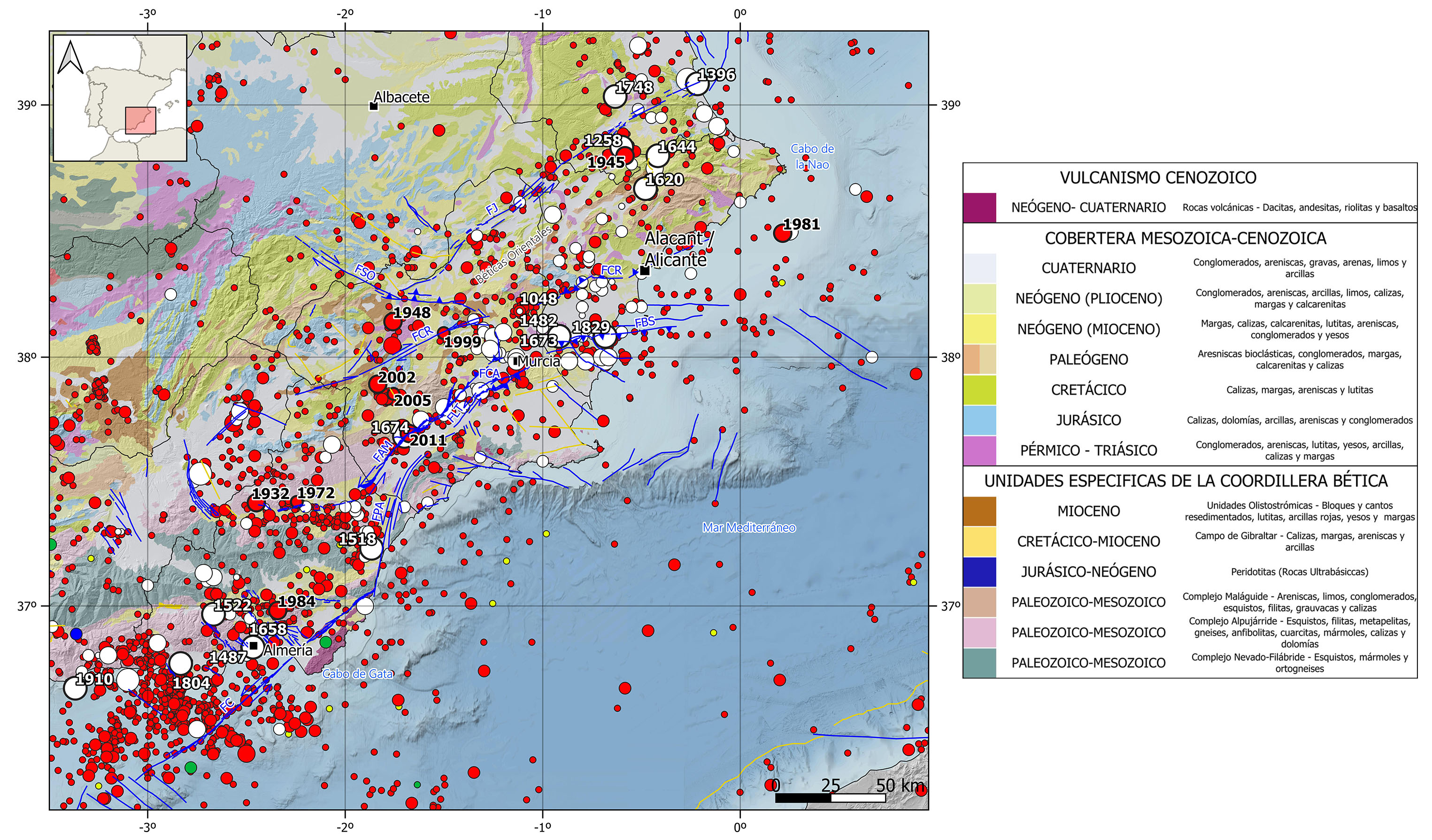
Seismic information source from the National Geographic Institute (IGN) (https://doi.org/10.7419/162.03.2022). Raster cartography of Spain from the IGN CC BY 4.0 ign.es. Geological data source: Thematic map of the National Atlas of Spain (ANE) CC BY 4.0 ign.es (2020), synthesis based on the IGME-SGE Geological Map of Spain 2M (2004) and the IGME-LNEG Geological Map of Spain and Portugal 1M (2015). 50% transparency. Main Quaternary active faults compiled from the QAFI data base (García-Mayordomo et al., 2012; ( IGME, 2022).FAM: Alhama de Murcia Fault, FBS: Bajo Segura Fault, FC: Carboneras Fault, FCA: Carrascoy Fault, FCR: Crevillente Fault, FJ: Jumilla Fault, FLT: Los Tollos Fault, FPA: Palomares Fault, FSO: Socovos Fault.
GEOLOGICAL CONTEXT AND TECTONIC FRAMEWORK
The eastern zone of the Betic Cordillera encompasses approximately all the region eastwards of Almería city. It extends along the Almería, Murcia and Alicante coastline till the Nao Cape and the northern boundary is set up by the provinces of Albacete and Valencia.
Geologically speaking, the northern sector in this region is dominated by the Outer Zone units, mainly represented by the Prebetic domain. The southern sector is governed by the Inner Zone units being the three forming complexes present, the Maláguide, the Alpujárride and the Nevado-Filábride. Both units are partially covered by cenozoic and quaternary sediments in those areas where there are neogene basins. Moreover, it is worth mentioning the volcanic rock outcrops presence, being the Gulf of Gata region the best-known example.
Tectonically, the Eastern Betic Cordillera is governed by the NNW-SSE compression derived from the convergence between the European and African plates (⁓5 mm/yr). This stress field is accommodated through several strike-slip faults mainly located in the center and south sectors on the region. These faults form a relevant 250 km long NE-SW corridor known as the Eastern Betic Shear Zone (EBSZ). It goes beyond the mainland limits and extends under water at both sides. It is the major active fault system in the Peninsula. It is mainly made up by NE-SW long strike-slip faults with slow displacement rates (1-2 mm/yr). There are many faults in this corridor reaching the surface and affecting recent quaternary deposits, clear evidence of the neotectonic activity related to the current stress field. The most relevant faults are, from south to north, Carboneras fault, 50 km long inland and 90 km long offshore to the SW, Palomeras, Los Tollos, Carrascoy and Bajo Segura faults, all aligned along over 100 km from Almería to Alicante, Alhama de Murcia fault, 90 km long and formed by 4 segments, and Crevillente fault, over 100 km long with many segments identified.
In the northern sector, where the Prebetic domain governs, the terrain is more stable. The NW-SE strike slip Socovos fault and the NE-SW strike slip Jumilla fault are the most important faults in the area.