TECTONIC FRAMEWORK
The Betic Cordillera uplift is included within the Alpine orogeny, a large-scale tectonic process active since the late Mesozoic and during most of the Cenozoic. This event is characterized in the mediterranean context by the convergence between the Eurasian and African plate.
In this compressive environment between Europe and Africa, in the most western part of the Mediterranean Sea, the Alboran microplate migrated westwards and tangentially collided with the Iberian plate. As a consequence, the arc-shape Betic-Rif orogen got uplifted and folded since the Miocene. The Betic System represents the northern portion of this orogen.
The Betic Cordillera shows a very complex structure as a result of the thrust of the Alboran plate over the Iberian plate, and the development of inner neogen basins during the extensive phases contemporary to the regional compression. Therefore, the mountain range uplift involved the thrust of the Inner Zone unit, in which the Maláguide, Alpujárride and Nevado-Filábride complexes thrust over each other, over the different Outer Zone domains, firstly over the oceanic crust of the Gibraltar Trough and the turbidites associated, and secondly over the Prebetic, Intermedate and Subbetic domains.
The Betic System is located along the diffuse boundary between the African and Eurasian plate. Currently, the NW-SE oblique convergence between these two plates is still active with a displacement rate around 5 mm/yr. Westwards, the convergence is more tangential. In this regional tectonic framework, accommodated by several folds and active fault systems, there are three zones with different characteristics: the Eastern, the Central and the Western. The Eastern zone is dominated by a NNW-SSE compression accommodated by many NE-SW strike-slip faults among which the left-lateral displacement Jumilla, Alhama de Murcia, Carrascoy, Palomares or Carboneras faults and the right-lateral displacement Crevillente fault are noteworthy. In the Central zone, the stress field is expressed by normal with strike-slip component fault systems with NNW-SSE strike that are linked to the intramountainous sedimentary basins of Baza, Guadix and Granada. In the Western zone, the presence of known active faults is scarce, but the seismicity recorded in the area corresponds to reverse and strike-slip faults.
REGIONAL OVERVIEW AND GEOLOGICAL CONTEXT
The Betic Cordillera is one of the biggest mountain ranges in the Iberian Peninsula. It is located in the southern and southeastern zone of the Peninsula and extends WSW-ENE from the Gulf of Cadiz to the Nao Cape on the Alicante mediterranean coast. It is 600 km long and 100 km on average wide. It holds several summits over 3000 m high among which stands out the Mulhacen peak, the highest peak in the Peninsula with a height of 3478 m above sea level.
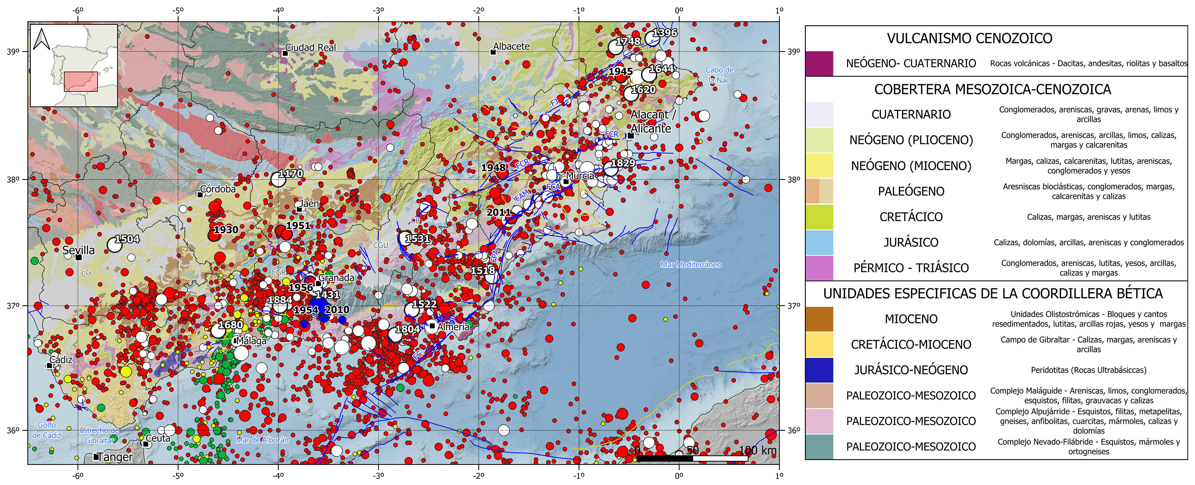
The Betic System corresponds to the northern portion of the Gibraltar Arc and extends eastward under the Mediterranean Sea, emerging back in the Mallorca Island to shape the Tramontana Mountain Chain. It is divided in two main units aligned in WSW-ENE direction. The first unit is called Outer Zone and covers the northern area of the mountain range, and it is bounded to the north by the Gualdalquivir River basin, the Iberian Massif and La Mancha plateau in Albacete. The second unit is called the Inner Zone and covers the southern area of the mountain range, and it is bounded to the south by the Alboran Sea.
Geologically speaking, these two units are different in terms of origin and evolution. The Outer Zone unit is developed on top of the iberian continental crust, and it is subdivided in two main domains, the Subbetic westwards and the Prebetic eastwards. Both domains are characterized by a strongly folded sedimentary cover formed by mesozoic and tertiary rocks mainly carbonatic, and they are separated by an Intermediate domain characterized by turbidite deposits. The Inner Zone is formed by the northern portion of the Alboran plate, where it is mainly continental, in which three different complexes are distinguished, the Maláguide, the Alpujárride and the Nevado-Filábride. These complexes are basically formed by marine rocks deposited during the Paleozoic and Cretaceous, and subsequently folded and metamorphized during the mountain range uplift.
Previously to the Betic System formation, the Inner and Outer Zone were located in two different tectonic plates separated by the Gibraltar Trough, early-stage ocean ridge where new oceanic crust was generated. Many cretaceous and paleogene turbidites were deposited in this area and they became part, together with the crust underneath, of the Betic System when it got formed. Currently, these turbidite deposits appear vertically as rock outcrops in the surroundings of Gibraltar, area known as the Flysh of the Campo de Gibraltar.
Moreover, during the mountain range uplift, on top of the Inner and Outer Zones, some intramountainous sedimentary basins were developed and infilled with mainly clastic neogene and quaternary deposits coming from the nearby rock erosion.
HISTORICAL AND INSTRUMENTAL SEIMICITY
The betics is the most seismically active region of the iberian peninsula. crustal earthquakes of shallow depth (<40 km) and low to moderate magnitude predominate, with the occurrence of some large destructive historical earthquakes. intermediate-depth seismicity (40-120 km) also occur in the western part of the cordillera, extending in an nne-ssw vertical trend from málaga to the moroccan coast. the existence of this seismicity has given rise to different theories about its origin, on which there is still no unanimous agreement. some of the most accepted theories are the existence of a subduction of the atlantic oceanic lithosphere under the gibraltar arc with an eastward dip that becomes practically vertical at depth or the occurrence of different delamination processes under the alboran sea.
Occasionally, there are also some very deep earthquakes located at more than 600 km depth with epicenter in the province of Granada. Their origin is also an open question, but some studies relate them to the presence of an anomalous velocity body observed in this area by seismic tomography, which could be connected or not to the body responsible for the intermediate seismicity, and which would be the product of ancient subduction processes or lithospheric delamination. In addition, it is interesting to note that no earthquakes with depths between 150 and 600 km have been recorded.
The crustal seismicity of the Betic System is largely controlled by the active fault systems that cross the Cordillera, and the predominant focal mechanisms vary according to the type of faults and stress field characteristic of each zone. While in the Eastern zone strike-slip focal mechanisms predominate, in the Central zone normal type mechanisms predominate and in the Western zone, where seismicity is scarcer than in the rest of the Betics, the reverse and strike-slip focal mechanisms predominate.
In the historical catalog, there are several significant destructive earthquakes in this region, mainly in the Eastern and Central Betic Cordillera, with estimated magnitudes between 6 and 6.5 and maximum intensities larger than VIII-IX. Among the largest earthquakes occurred in the Betics northeastern end there are worth mentioning the 1396 Tavernes de Valldigna and the 1748 Estuveny (Valencia) events, and the 1620 and 1644 Alcoy and Muro de Alcoy (Alicante) events. Further south, in the province of Almería, there are noteworthy the 1518 Vera, 1522 Alhama de Almería, and the 1804 Dalías earthquakes. In the Central zone, some of the most important events are the 1170 Andújar (Jaén), the 1431 south of Granada, and the 1531 in the Baza Basin (Granada) earthquakes. In the Western zone, the 1504 Carmona (Sevilla) event, located in the Guadalquivir Basin to the northwest of the Cordillera, and the 1680 Alhaurín el Grande (NW Málaga) event are remarkable. But the largest and most virulent historical earthquakes occurred in this region are the 1829 Torrevieja (Alicante) and the 1884 Arenas del Rey (Granada) earthquakes. Both were felt with a maximum intensity of IX-X and have an estimated magnitude around 6.5.
However, in the instrumental catalog, the largest recorded earthquakes are very deep earthquakes, located south of the city of Granada at depths larger than 600 km, the 1954 Dúrcal (M7.8) and the 2010 Nigüelas (M6.3) earthquakes. At shallow depths, the highest magnitude seismicity occurred in the Betic Cordillera is of magnitude around 5 and maximum intensity of VII. In the Western zone, it is remarkable the 1930 Montilla (Córdoba) event; in the Central zone, two events in 1951 to the southwest of the province of Jaén and the 1956 Purchil (in the Granada basin) earthquake stand out; and in the Eastern zone, are noteworthy the 1948 Cehegín (Murcia), the 1945 Onteniente (Valencia) earthquakes and the most recent one in 2011 in Lorca (Murcia), which caused nine deaths and numerous damages to buildings in Lorca.