MARCO TECTÓNICO
La actual configuración del noroeste peninsular es resultado de una compleja evolución tectónica en la que podemos distinguir tres fases principales.
Una primera fase compresiva vinculada a la orogenia Hercínica, en la que se origina el Macizo Ibérico. Esta orogenia se desarrolló en varias fases a lo largo de gran parte del Paleozoico medio y superior y fue consecuencia de la colisión de las grandes masas continentales de Euroamérica y Gondwana dando lugar al supercontinente Pangea.
Una segunda fase distensiva a lo largo del Mesozoico, en la que se produjo la apertura del océano Atlántico con la consiguiente ruptura de Pangea. Por su parte, el margen norte peninsular se vio condicionado por el giro antihorario hacia el SE de la placa ibérica, que, al hacerlo de forma independiente al resto de Europa, supuso su separación de Eurasia y la consiguiente apertura del golfo de Bizkaia.
Y una tercera fase compresiva durante el Cenozoico, relacionada con la orogenia Alpina, la cual se originó por la colisión de la placa ibérica con la placa euroasiática y africana. Esto supone un giro completo del contexto geodinámico anterior, y como consecuencia de la convergencia entre Eurasia e Iberia, en el margen norte de la península ibérica, se produce el cierre parcial del golfo de Bizkaia y el levantamiento de la Cordillera Cantábrica.
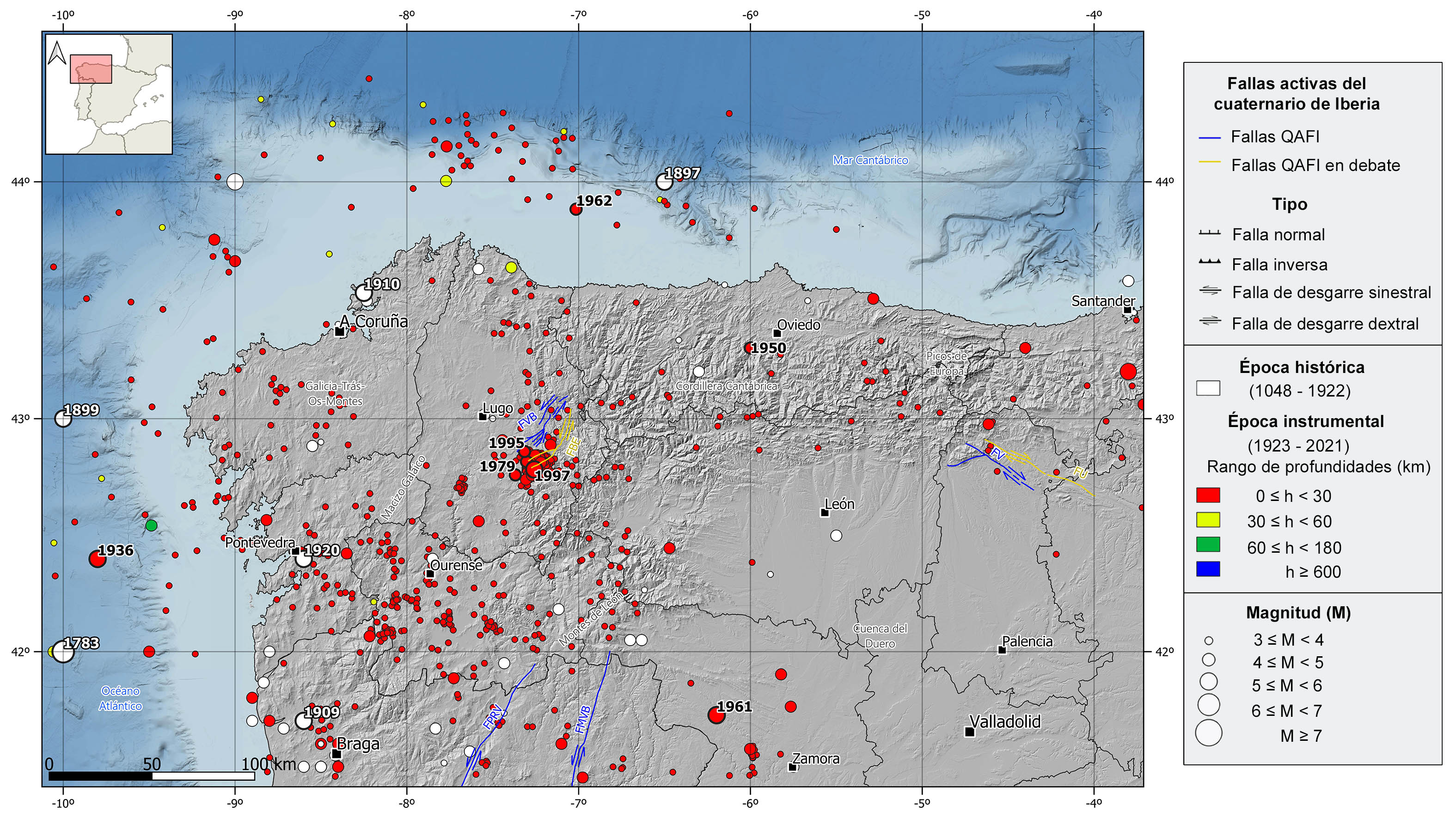
Consecuencia de esta compleja historia tectónica, existen en la zona numerosas fallas de tipo inverso o desgarre de edad paleozoica, reactivadas como fallas normales en la fase distensiva y que recuperaron sus mecanismos inversos y de desgarre durante la orogenia Alpina. Algunas de estas fallas muestran evidencias de actividad reciente (Plioceno y Cuaternario) y sismicidad asociada. Destacan tres sistemas de fallas de desgarre sinestral, el de Vilachá-Baralla-Becerreá en Lugo, que presenta una orientación NE-SO, y los de Penacova-Régua-Verín y Manteigas-Vilariça-Bragança, localizados en el NE de Portugal, y tienen orientación NNE-SSO. También es reseñable el sistema de fallas de desgarre dextral de Ventaniella y Ubierna al sureste de la Cordillera Cantábrica con orientación NO-SE. La falla de Ventaniella, aunque sólo es activa en su segmento meridional, se extiende más de 200 km en tierra y continúa otros 150 km en mar.
DESCRIPCIÓN REGIONAL Y CONTEXTO GEOLÓGICO
Esta región abarca todo el margen noroccidental de la península ibérica, extendiéndose desde el extremo occidental de Cantabria hasta la costa atlántica gallega a lo largo de casi 400 km, y hacia el interior incluyendo toda Galicia y la mayor parte de la vertiente norte de la cuenca del Duero. La zona norte y oeste es una región montañosa que comprende la parte occidental de la Cordillera Cantábrica, incluyendo los Picos de Europa, los Montes de León y el Macizo Galaico, con un litoral muy recortado con grandes acantilados y sin apenas llanuras costeras, mientras que el sureste es una zona de meseta que corresponde a la cuenca del Duero.
Desde el punto de vista geológico, esta región corresponde principalmente a la zona norte del Macizo Ibérico, que es el conjunto de materiales paleozoicos y precámbricos deformados y metamorfizados fundamentalmente durante la orogenia Hercínica o Varisca. Esta orogenia generó un cinturón montañoso, actualmente muy erosionado y parcialmente enterrado, que en Europa se extiende a lo largo de más de 3000 km desde el río Guadalquivir hasta Centro-Europa y los Balcanes. El Macizo Ibérico representa la parte meridional de este cinturón y es el mayor registro conocido de los efectos de la orogenia Hercínica.
El Macizo Ibérico domina los afloramientos rocosos de la mitad occidental de la península ibérica y queda enterrado en la cuenca del Duero donde actúa como basamento. Los sedimentos que rellenan esta cuenca de edad cenozoica son fundamentalmente de tipo clástico continental y su generación y deposición está ligada a la orogenia Alpina.
El Macizo Ibérico se subdivide en 6 zonas, 3 de las cuales quedan incluidas en el noroeste peninsular. De este a oeste tenemos, la zona Cantábrica, parte externa del orógeno Varisco donde dominan los sedimentos marinos intensamente deformados pero con bajo grado de metamorfismo, conservando así el carácter sedimentario las rocas, la zona Asturoccidental-Leonesa, zona de transición entre la parte externa e interna y por tanto con un mayor grado de metamorfismo, y la zona Centro-Ibérica, región axial o central del orógeno Hercínico donde dominan rocas con un alto grado de metamorfismo e intrusiones graníticas abundantes. En esta última zona cabe destacar la subregión de Galicia-Tras-os-Montes donde se distinguen diversos complejos ofiolíticos, fragmentos de corteza oceánica obducidos durante la orogenia Hercínica.
SISMICIDAD HISTÓRICA E INSTRUMENTAL
Desde el punto de vista sísmico, el NO de la península ibérica se considera actualmente una zona estable con una sismicidad de magnitud baja o moderada, dentro del contexto sismotectónico general de Iberia. No obstante, presenta algunas series sísmicas y terremotos de magnitud moderada. La sismicidad en esta zona es superficial (profundidades <30 km) y, aunque escasos, predominan los mecanismos focales de tipo normal y desgarre. El sur y este de Galicia es la zona con mayor número de terremotos, mientras que en el resto de la región la sismicidad es dispersa, con algunos sismos con epicentro marino, tanto en la vertiente atlántica como en la cantábrica.
En el catálogo histórico podemos resaltar varios terremotos de magnitudes estimadas superiores a M5. Con epicentro en el mar, destacan los terremotos de 1783 y 1899 en el océano Atlántico, y el de 1897 en el mar Cantábrico, sentidos con intensidades máximas de VI-VII, VI y V-VI respectivamente. En tierra, destacan tres terremotos sentidos con intensidad VII, en 1909 en Viana do Castelo (Portugal), 1910 en El Ferrol y en 1920 en Pontevedra. Además de éstos, en las dos primeras décadas del siglo XX, hay catalogados varios terremotos de intensidad VI y magnitud ligeramente inferior a M5, principalmente en el noroeste de Portugal y suroeste de la provincia de Pontevedra.
En la época instrumental, cabe señalar tres terremotos de magnitud en torno a M5 sentidos con intensidades máximas de VI, el terremoto de 1950 en Teverga (al suroeste de Oviedo) de M4,7 y dos terremotos ocurridos en 1961 al oeste de Zamora de M5,3. Pero la mayor parte de la sismicidad se concentra en la zona de Sarria-Becerreá-Triascastela (Lugo), donde destacan tres series sísmicas en 1979, 1995 y 1997 con terremotos de hasta M4,6, M4,7 y M5,2 respectivamente. Con epicentro en el mar, también destacan dos terremotos de magnitud moderada sentidos con intensidades máximas de V y VI, el de 1936 de M5,1 en el Atlántico, frente a las costas de Pontevedra, y el de 1962 de M4,4 en el mar Cantábrico frente a las costas de Lugo. En los últimos 20 años, se han registrado algunos terremotos dispersos con magnitud ligeramente por encima de 4,0 sentidos con intensidades entre IV y V, en el interior en las provincias de Zamora y León y en el mar, tanto en la vertiente cantábrica como atlántica.