TECTONIC FRAMEWORK
The Iberian Chain is a large intraplate structure raised during the Alpine orogeny. This orogeny, caused by the collision of the Iberian plate with the Eurasian and African plates along the Cenozoic, lead to a compressive stress field that resulted in the uplift of the two main mountain chains in the Iberian Peninsula, the Pyrenees and the Betic System. The Iberian Chain is located between these two major mountain ranges and was formed by the uplift and folding of previously existing mesozic extensional sedimentary basins (tectonic inversion) in the central and eastern region of the Peninsula.
Despite the Iberian Chain is tectonically independent from the Coastal Catalan Range, they do share origin and age. In the linkage or transition zone between both mountain ranges, the NW-SE Iberian Chain and NE-SW Coastal Catalan Range structures interfere. This transition zone extends from the northern area of the Maestrazgo to the south of the Tivissa mountains to the north.
After its uplift, the system changed to be controlled by an extensive regime linked to the opening of the Valencia Trough. The rift system forming the Valencia Trough continues northwards entering the European continent. It began to open in the Miocene and defined the current position of Corsica and Sardinia Islands, as well as the Balearic Islands. Firstly, the dominant extensive stress field was ESE-WNW direction, but currently, the stress field is much complex and multidirectional due to the thermal subsidence phase that currently governs the region.
During this extensional regime, new neogene-quaternary basins appeared. These basins show a significant number of normal faults with evidence of recent activity or even associated instrumental seismicity. The central area basins are characterized by NW-SE to N-S faults; the best examples are the Teruel basin dominated by El Pobo fault system and the Teruel fault, the Calatayud basin bounded by the Vicort, Munébrega and Daroca faults, and the most recent basin of Jiloca, limited to the East by three ‘en-échelon’ normal faults (Calamocha, Sierra Palomera, and Concud).
However, the normal faults in the eastern region of the Iberian Chain are oriented in a NE-SW direction. The best example is the coastal area of the Maestrazgo where many active faults are located, like the Amposta fault system that corresponds to the southwards continuation of the fault system of the Coastal Catalan Range. It is also remarkable the surrounding area of Valencia city where various active faults with associated seismicity are known and controlled by a more complex tectonic regime due to the impact of transpressional forces coming from the Eastern Betic System. The NW-SE to NE-SW Cullera faults stand out within this fault group.
Therefore, the Iberian Chain is an intraplate zone with a moderate degree of deformation, and it is characterized by the presence of active normal faults with orientations ranging from NW-SE to NE-SW and slow movements mostly below 0.1 mm/year.
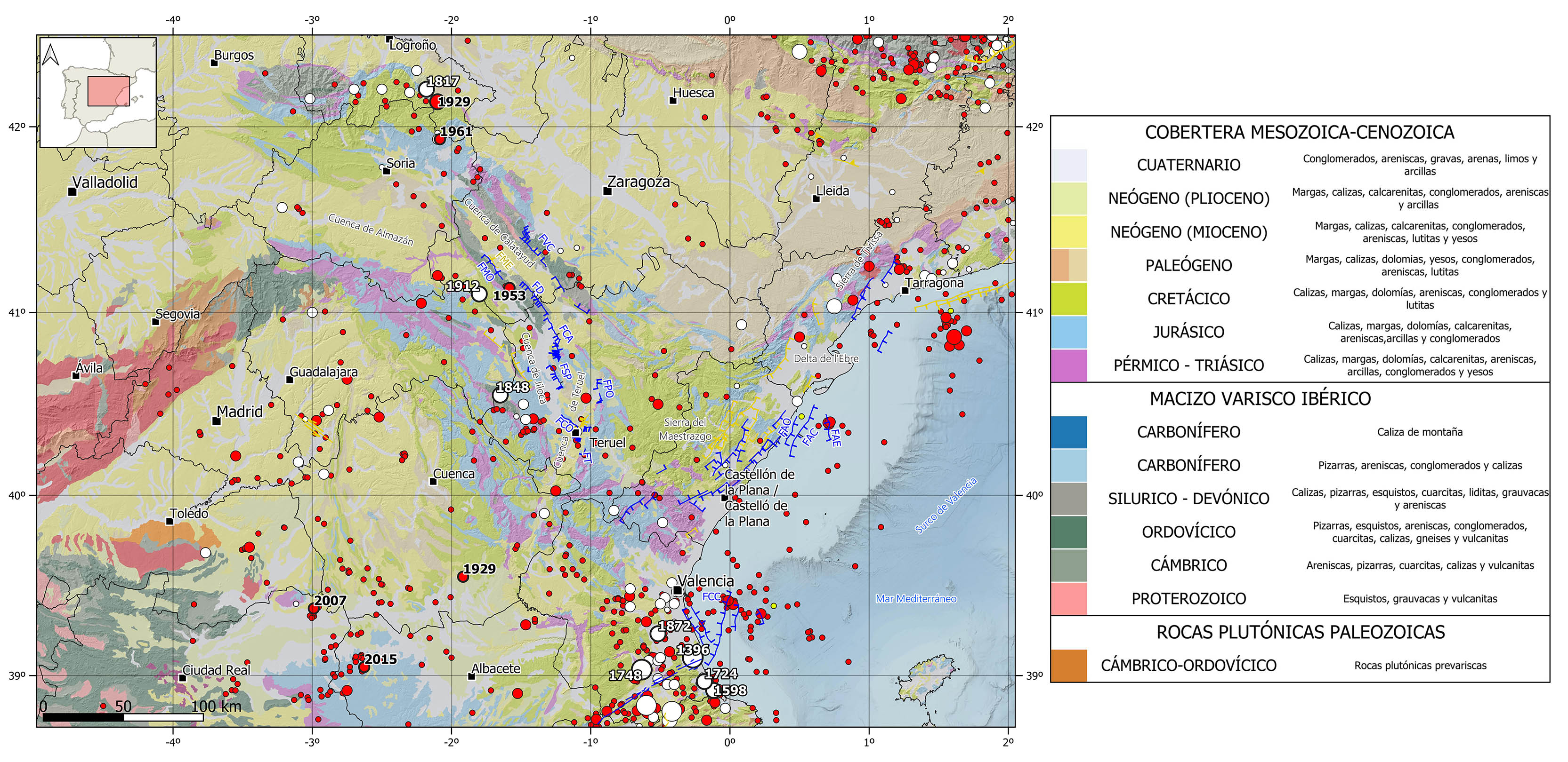
REGIONAL OVERVIEW AND GEOLOGICAL CONTEXT
This region encompasses both the Iberian Chain and the southernmost part of the Valencia Trough.
The Iberian Chain is over 400 km long and 100 km wide on average. It extends in NW-SE direction from the middle east edge of the province of Burgos to the mediterranean coast in the Comunitat Valenciana. It is linked in its southern area to the Coastal Catalan Range through El Maestrazgo region. This mountain range is the watershed between the three major hydrographical basins in the Iberian Peninsula (Ebro, Duero, and Tajo).
It is formed by the Aragonese and the Castilian branches, which are separated by the Almazan basin. The Aragonese branch is as well divided in two parallel ridges separated by the Calatayud basin. Some summits in the cordillera reach heights over 2,000 m, being the Moncayo peak the highest one with 2,315 m high.
In the Mediterranean Sea, the Iberian Chain joins the Valencia Trough which is a marine basin that extends from Valencia to Girona, including the Balearic Islands.
Geologically speaking, this region presents a high variety of lithologies from a wide range of ages. Despite the oldest rocks are from precambrian times, the paleozoic rocks (granites and metamorphic rocks) form the Variscan basement on which the main sedimentary cover is deposited discordantly. These sedimentary rocks include mesozoic series, mainly carbonatic, up to 5 km thick, and cenozoic series mainly formed by clastic rocks.
HISTORICAL AND INSTRUMENTAL SEISMICITY
This region is characterized by a low to moderate seismicity, with the occurrence of some destructive historical earthquakes. The epicenters are mostly concentrated in the southeastern and northwestern sectors of the mountain range, with some scattered earthquakes in the central zone. It is a shallow crustal seismicity (<25 km depth), with hypocenters mainly located between 5 and 15 km depth. The available focal mechanisms in the area, although scarce, are consistent with the current extensional tectonic regime, with predominance of normal fault type sources.
In the historical catalog, in the northern and central part of the Iberian Chain, it is worth mentioning the 1817 Prejano (La Rioja) earthquake with maximum intensity VII-VIII, 1848 Orihuela del Tremendal (Teruel), and 1912 Cimballa (Zaragoza) earthquakes, both felt with maximum intensity VI-VII and estimated magnitude above 5. In this area there have also been several events with an estimated magnitude slightly lower than 5 and a maximum intensity of VI. In the southeast sector, in the boundary with the northeasternmost Betics, some significant historical destructive earthquakes reaching intensity IX and estimated magnitude larger than 6 have been catalogued in the province of Valencia. This is the case of 1396 Tavernes de Valldigna earthquake, which caused the collapse of hundreds of houses in Tavernes, and the 1748 Estubeny earthquake, which destroyed de towns of Montesa, Sellent and Estubeny. Other noteworthy events of estimated magnitude above 5 are the 1598 Oliva, with intensity VII-VIII, and the 1724 Gandía and 1872 Carlet earthquakes, both with intensity around VII.
In the instrumental period, in the northern sector of the Iberian Chain, we can highlight the 1929 (M5.2) Turruncún (La Rioja) earthquake, with intensity VI-VII, as well as several events of magnitude slightly larger than 4.5 and felt with maximum intensities between VI and VII. Such as the 1929 Motilla Palancar (Cuenca), 1953 Used (Zaragoza), or the 1961 Aguilar Rio Alhama (Logroño) earthquakes. However, the southeastern region of the mountain range has not suffered any significant earthquake over the last century. Nevertheless, it is noteworthy some seismicity at sea, in the Gulf of Valencia, where the 2003 seismic series stands out, with the largest earthquake of magnitude 4.2 felt with intensity V. More recently, to the southwest of the Iberian Chain, two earthquakes are worth mentioning: the 2007 Pedro Muñoz (Ciudad Real) and the 2015 Ossa de Montiel (Albacete) events, both of magnitude 4.7 and felt with a maximum intensity of V.