TECTONIC FRAMEWORK
The tectonic framework in this region is controlled by its location on the Eurasian and African plate boundary and its interaction with the orogenic Gibraltar Arc. The oblique collision between these two plates was mainly active during the Alpine orogeny, large scale tectonic process that spanned from the late Mesozoic to the late Cenozoic and caused the uplift of the Betic and Rif mountain ranges. Nowadays, this plate collision is still active in WNW-ESE direction in this region with a displacement rate close to 5 mm/yr. Consequently, the dominant stress field in the area is compressive with strike-slip component, therefore, the Gulf of Cadiz and its continuation up to the Gorringe Ridge accommodate the oblique convergence between the two continental tectonic plates.
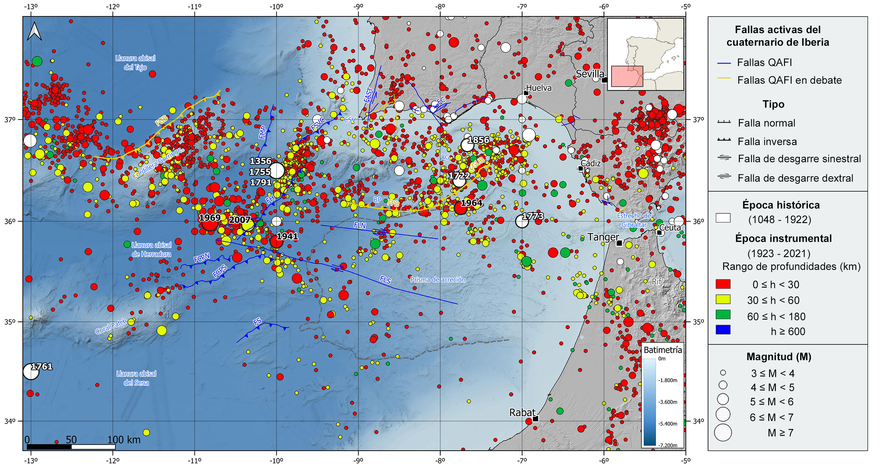
Westward of this region, the African and Eurasian plate boundary is well defined by the Azores fracture (transform fault) that reaches the western portion of the Gorringe Ridge. However, eastwards to this submarine ridge, this boundary gets diffused with no single fracture zone defined. As a result, the complex stress field in the area is accommodated through some reverse and strike-slip fault systems distributed in a large area corresponding the plate boundary in the region.
The most important active faults in the area are the NE-SW strike and SE dipping inverse or thrust faults of Marqués de Pombal (FMP), San Vicente (FSVC), Gorringe (FGB, under debate), Horseshoe (FH), North and South Coral Patch (FCPN, FCPS) and Seine (FS). Near the coast and in arch shape, there are two reverse faults with opposite dip under debate called the Portimao (FPB) and Guadalquivir (FGUB) Bank faults. In the central part of the Gulf of Cadiz, affecting the accretionary prism, there are two remarkable WNW-ESE right-lateral strike slip parallel faults known as North and South Alignment (FLN, FLS). Another remarkable active fault complex extends along the southern coastline of Portugal and consist of different orientation faults like the left-lateral strike slip and reverse Aljezur-S. Teotónio (FAST) and Carvacai (FC) faults.
Despite they are more difficult to map, there are many listric and normal faults in the accretionary prism, some of them active.
REGIONAL OVERVIEW AND GEOLOGICAL CONTEXT
This region encompasses the Gulf of Cadiz and its westward continuation along the Eurasian and African plate boundary up to the Gorringe Ridge. The Gulf of Cadiz is a marine basin that includes the Atlantic Ocean inlet around the SW coast of the Iberian Peninsula, from the Cape St. Vincent to the Strait of Gibraltar, and the NW coast of Morocco.
It is a large region evolving from the shallow water continental platform along the coastline to the abyssal zone in the western area where the water column goes beyond 4,500 m. The continental slope connects both domains, oceanic and continental, and it is shaped by significant submarine canyons determined by the basement highs, for example the Guadalquivir and Portimao Highs.
In the abyssal zone there are some seamounts mostly corresponding to extinct volcanoes that never emerged. The NE-SW Gorringe Ridge, 200 km long and 70 km wide, and the ENE-WSW Coral Patch Seamount, 100 km long and 50 km wide, are the most relevant seafloor reliefs in this region and split the abyssal zone into three different plains, from north to south, Tajo, Horseshoe and Seine.
Geologically speaking, it is a complex region formed by different crustal domains, thinned paleozoic continental crust along the iberian and african continental margins, jurassic oceanic crust covering the central and southwestern area, and crust coming from exhumed mantle during the early cretaceous in the northwestern area. The Gulf of Cadiz region is bounded by the Iberian Massif and the Algarve basin to the north, and the orogenic Betic-Rif Arc to the east, which is the most western alpine mountain range in the mediterranean context.
On top of this heterogeneous and rugged basement there is a discordant sedimentary cover formed by several units of ages ranging from the Mesozoic to the Quaternary and with variable thicknesses up to few kilometers. Within this units, the allochthonous or accretionary prism unit, spread in wedge shape all over the central part of the gulf, is the main sedimentary infill in the region in terms of thickness and distribution. This unit consist of imbricate layers moving forward successively offshore reaching progressively higher distances. It is also remarkable in this region the presence of many clay and salt diapirs as well as mud volcanoes.
HISTORICAL AND INSTRUMENTAL SEIMICITY
This area is characterized by a moderate-magnitude seismicity, although some of the largest known earthquakes in the surroundings of the Iberian Peninsula have also occurred, constituting one of the regions with highest tsunami hazard in the Atlantic Ocean. In fact, in this area, three earthquakes that have generated tsunamis and affected the Spanish coasts have been catalogued. In addition, other events within this region have caused tsunamis that have affected at least the Portuguese coasts.
The seismic activity in this region reflects the complex convergence between the African and Eurasian plates in the area, without any clear epicentral alignment. In fact, most earthquakes are distributed in clusters, mainly located in the northern half of the Gulf of Cadiz, extending to the western part of the Gorringe Bank. This seismicity seems to be generated in the lithospheric mantle rather than in the crust, with hypocenters located mainly between 30-40 km depth and, in some cases reaching 50-60 km depth, but without clearly drawing a subduction zone. This could be explained by a fragile behavior of the old and cold oceanic lithosphere up to the upper mantle. Although there is still poor knowledge of the relationship between this seismicity and the geologically mapped active faults in the area, most of the available focal mechanism are reverse and strike-slip types with a maximum horizontal compression in the NW-SE direction.
Historically, the largest and most important earthquake ever recorded is the 1755 earthquake, also known as the Lisbon earthquake. Located SW Cape St. Vincent, it has an estimated magnitude of 8.5 and was felt in the south of Portugal with a maximum intensity of X, all western Europe, and North Africa. This earthquake generated a tsunami with waves reaching 10-15 meters height in the Gulf of Cadiz. In the westernmost end of this region, it is also noteworthy the 1761 earthquake, located to the SW of the Coral Patch Seamount, with a similar estimated magnitude of 8.5, reached a maximum intensity of IX. This earthquake was also felt in different areas of Europe and caused a tsunami that reached the coasts of Portugal, Spain, Great Britain and even Barbados, although with much less severity than that of 1755. Other important historical earthquakes are those occurred in 1356 and 1791, located to the southwest of Cape St. Vincent, in the vicinity of the 1755 earthquake. The former was felt with a maximum intensity of VIII and has an estimated magnitude around 7.6, the latter with a maximum intensity of VI and estimated magnitude around 6.2. In the Gulf of Cadiz, it is worth mentioning the 1722 earthquake, with an estimated magnitude of 6.0, which devastated several localities in the south of Portugal, where reached intensity VIII, and caused a local tsunami that flooded shallow areas of Tavira. Further south, also remarkable is the 1773 earthquake, with an estimated magnitude of 6.5, and felt with a maximum intensity of VII. Offshore Portugal there was also an earthquake in 1856 with an estimated magnitude of 6.2 and felt with a maximum intensity of VII-VIII.
In the instrumental period, the most important earthquake in this area was the 1969 earthquake (M7.8), located southwest of Cape St. Vincent, in the Horseshoe abyssal plain. This earthquake was felt with maximum intensities of VIII-IX and VIII in several locations in southern Portugal and produced a small tsunami on the coasts of Morocco, Portugal and Spain. Also noteworthy are the 1941 earthquake (M6.7) and the 1964 earthquake (M6.6) in the Gulf of Cadiz, which was felt with a maximum intensity of VII. More recently, two earthquakes occurred in 2007 (M6.1) and 2009 (M5.7), located in the vicinity of the 1969 and 1755 earthquakes, respectively, both felt with a maximum intensity of IV.